
Sanjen (Upper) Hydroelectric Project (SUHEP)
Sanjen (Upper) Hydroelectric Project (SUHEP)
PROJECT DESCRIPTION
Sanjen (Upper) Hydroelectric Project (SUHEP):
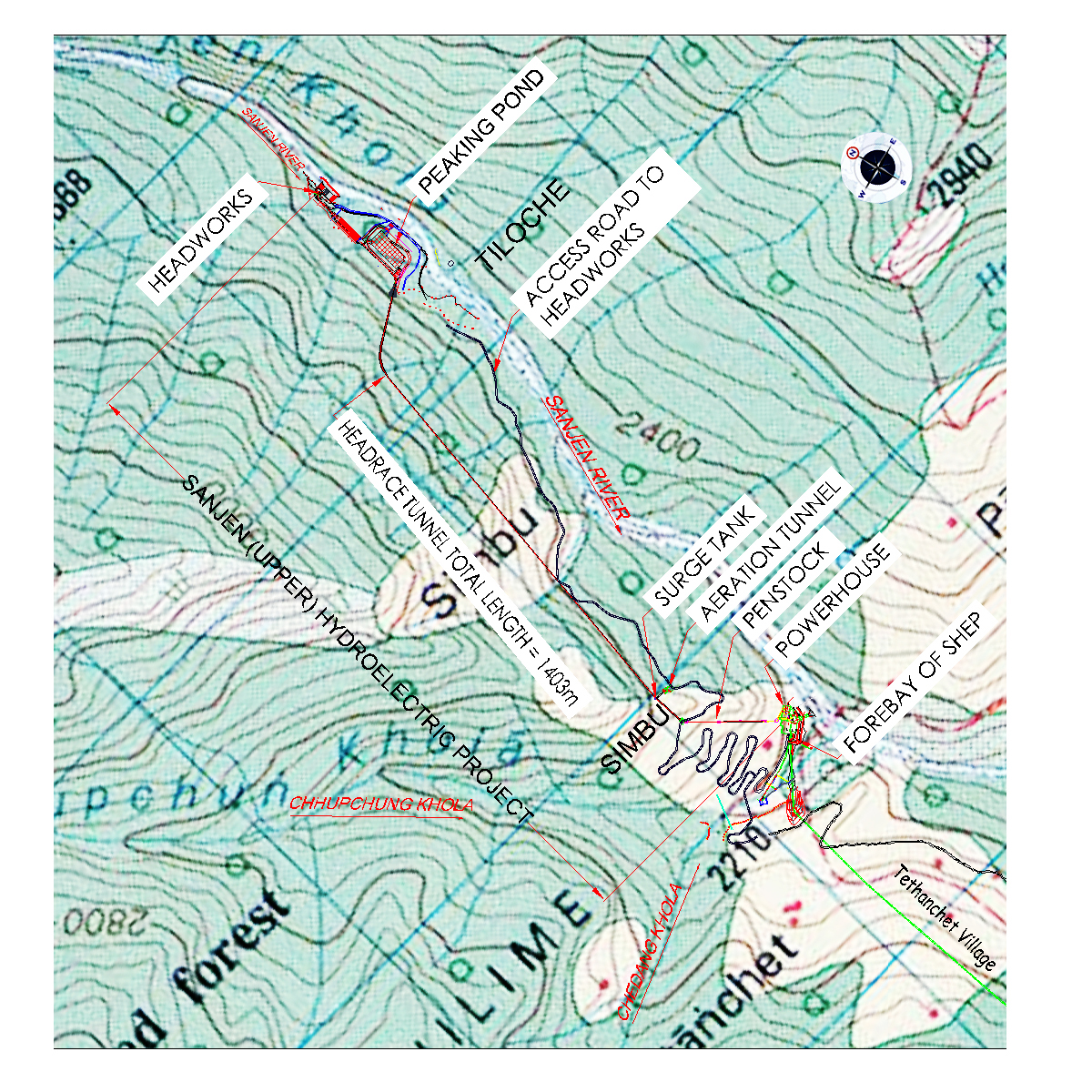
Sanjen (Upper) Hydroelectric Project is a run-of-river scheme with daily peaking facility for 1 hour 10 minutes. The whole scheme is divided into three work sites, viz.Headworks Site that covers diversion weir, undersluice, intake, gravel trap, spillway, desanding basin, peaking pond, forabay and pressure conduit, Underground Works that covers headrace tunnel, rocktrap, surge tank, penstock tunnel and construction adits, and Powerhouse Site that covers surface penstock, powerhouse structure, tailrace and switchyard.
The headworks site is located at Tiloche of Chilime VDC. The headworks consist of overflow diversion weir of height 3.3m and one number of undersluice of size 3m wide and 3m high, side intake structure of 12m long, gravel trap of size 25 m long and 4.2 m wide, dufour type double chamber surface desander basin of size 60m long, 8.5 m wide and 6 m deep, peaking pond of size 138 m long and 65 m wide, forebay and 30m long low pressure conduit connecting to the headrace tunnel portal.
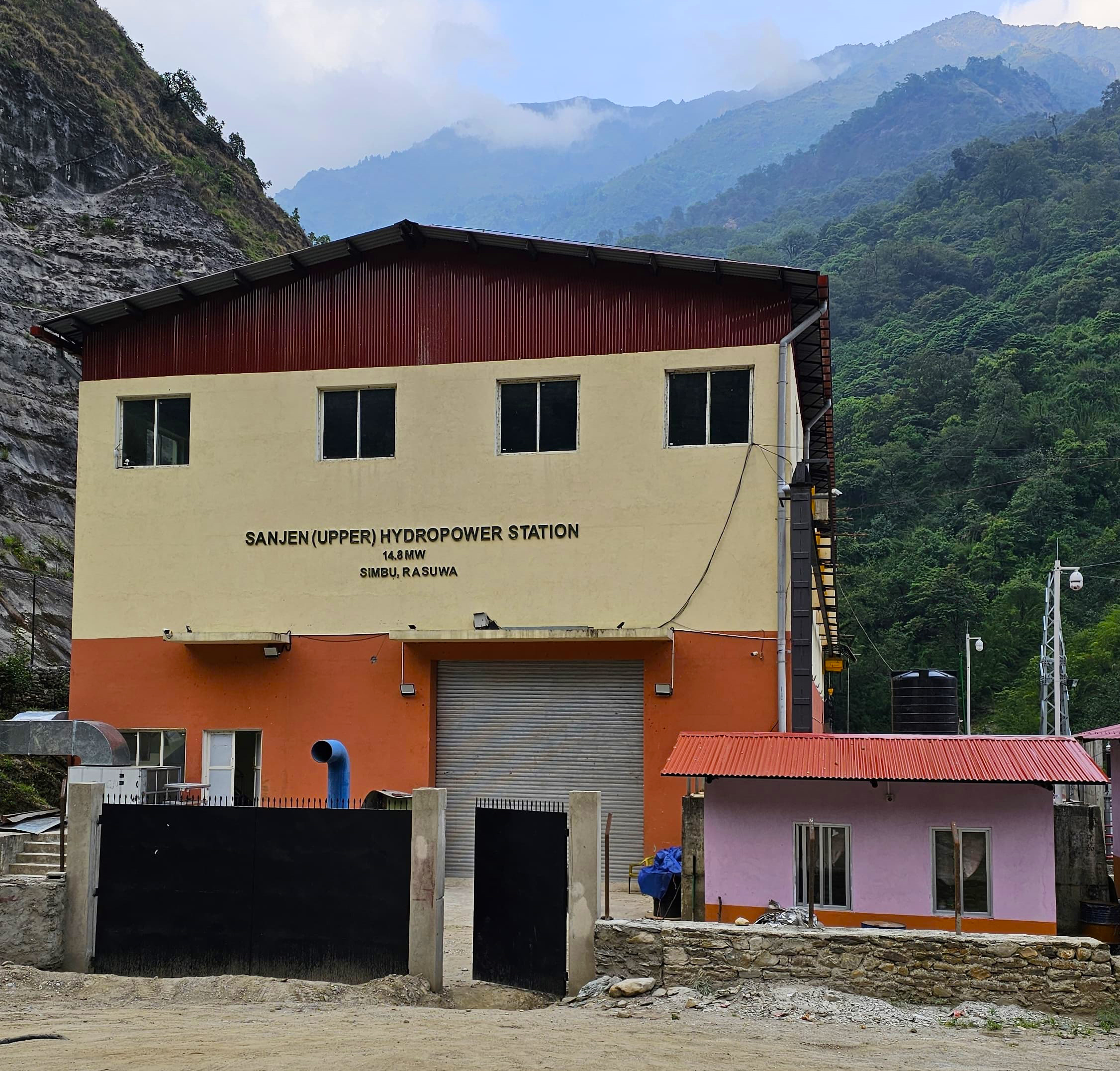
Headrace tunnel is 1378m long, inverted D shape of excavated section 3.5m x 3.75m. Surge tank is simple cylindrical type of height 40m and diameter 6m. Surface powerhouse is located at Simbu Village of Chilime VDC. Powerhouse accommodates three units of horizontal axis Francis turbines of capacity 5.1 MW each and three units of 3-phase synchronous AC generators of capacity 5.85 MVA each. Three numbers of tailrace canals each of 5 m long discharges the tail water to the Forebay/Intake of Sanjen Hydroelectric Project (SHEP). Surface switchyard is located adjacent to the powerhouse complex.
HYDROLOGY
The Sanjen River, a snow-fed river, serves as the primary water source for the Sanjen (Upper) Hydroelectric Project (SUHEP). The catchment area at the SUHEP weir site in Tiloche is approximately 180 km², with only 4 km² lying below the 3,000-meter elevation. At the SUHEP powerhouse site in Simbu, the catchment area extends to about 190 km². Annual precipitation in this region averages 1,143 mm, with monsoon precipitation accounting for 958.7 mm. Long-term mean monthly flow data at the SUHEP weir site reveal a maximum of 42.49 m³/s in August and a minimum of 2.33 m³/s in February. The design flow is set at 11.07 m³/s, corresponding to a 40% exceedance probability (Q40), and the 100-year design flood is estimated at 194 m³/s.
The tailwater from SUHEP feeds directly into the intake of the downstream Sanjen Hydroelectric Project (SHEP), a cascade run-of-river system.
GEOLOGY
The project area is situated in the Higher Himalaya and the Lesser Himalaya, Central Nepal
Diversion weir lies on the stable and relatively flat channel of the Sanjen River. It is characterized by about 3-4 m thick alluvial deposits consisting of predominately coarse gravel to boulder derived from gneiss, schist and quartzite in sand matrix with large boulders of augen gneiss. Desanding basin, peaking reservoir and forebay lie on a flat alluvial terrace.
Common rock types along the tunnel alignment, surge tank and penstock tunnel are fair to good and are therefore, suitable for the underground works. Penstock is partly underground and partly surface. Powerhouse will be founded on the bed rock.
Status of the Project
Power generated from this Project is being transmitted via a 132 kV transmission line connecting to the Chilime Hub. From there, the power is further conveyed through the Chilime-Trishuli 220 kV transmission line. The Commercial Operation Date of SUHEP is 8 October 2023.
PROJECT LAYOUT MAP
SALIENT FEATURES
| Location | Aamachhodingmo – 5, Chilime, Rasuwa district. |
| Developer | Sanjen Hydropower Company Limited |
| Type of Project | Peaking Run-Of-River |
| Hydrology | |
| Catchment area (Dam site) | 180 km2 |
| 90% dependable flow | 2.4 m3/s |
| Design flow (Q40) | 11.07 m3/s |
| Design flood (Q100) | 194 m3/s |
| Geology | |
| Rock Type: | Medium grade metamorphosed schist and quartzite |
| Head | |
| Gross | 161.30 m |
| Net | 156.0m |
| Headworks | |
| Weir | 14 m (l) x 3.30 m (h) |
| Undersluice Single Bay | 3.0 m wide |
| Intake Type | Side Intake |
| Intake Size | 2 Nos, 5.50 m (w) x 1.40 m (h) |
| Desanding Basin | |
| Type | Surface Dufour Type Double Chambre |
| Size | 60 m (l) x 8.5 m (w) x 7.13 m (h) |
| Peaking Pondage | |
| Gross Storage | Capacity 40,000 m3 |
| Normal Water Level | 2347.55 m |
| Headrace Tunnel | |
| Length | 1386.00 m |
| Section | 3.50 m (w) x 3.75 m (h) : D- shaped |
| Surge Tank | |
| Type | Simple Cylindrical |
| Size | 40.00 m (h), 6 m (dia) |
| Penstock | |
| Type | Underground |
| Size | 500 m (l), 1.1~2.5 m (dia) |
| Powerhouse | |
| Type | Surface |
| Size | 46.60 m (l) x 12.00 m (b), 20.00 m (h) |
| Tailrace | 30 m (l) x 3 m (b) x 5 m (h) |
| Turbine | |
| Type | Francis, Horizontal Axis |
| Capacity | 3 Nos., 5.1 MW each |
| Generator | |
| Type 3 | Phase Synchronous AC |
| Rated Power | 3 Nos., 5.85 MVA each |
| Installed Capacity | 14.8 MW |
| Annual Energy Generation | 85.87 GWh |
| Dry Months Energy | 11.02 GWh |
| Wet Months Energy | 74.85 GWh |
| Salable Energy | 82.439 GWh |
| Dry Month Energy | 10.58 GWh |
| Wet Month Energy | 71.85 GWh |
| Transmission Line | |
| Length | 5 km |
| Voltage | 132 kV |